|
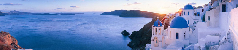 |
About Santorini island Greece
 |
Santorini has about fifteen thousand inhabitants during the winter time and
approximately forty thousand in the summer. Santorini is a crescent shape surrounding the black volcanic islands lying in the bay. What was once the island of Thira sank to the bottom of the caldera in the apocalyptic explosion in 1450BC. The lagoon-like caldera measures 32 square miles and is 300 to 400 meters deep. In the center are Palea Kameni and Nea Kameni.
Santorini is one of
the southernmost
islands of the
Cyclades in the
Aegean Sea. Its
distance from
Piraeus is 128
miles, from Iraklion
Crete 68 miles and
from Rhodes 147
miles.
In its present form
Santorini has an
area of 76 sq.kms
and a population of
15.000. Its coastline is 70kms long.
The whole group
consists of the Thirassia, Aspronisi,
Palia Kameni, Nea
Kameni and Mikri
Kameni.
There are 14 villages including Fira, the capital
of Santorini island
which is full of motion and night life. Each one of the villages has its own character, while all together create the unique Santorini atmosphere. On the western side where the volcano is located, the sheer cliffs, 300 meters high, are multi-colored strata of black, red, grey, and brown.
The villages include:
Akrotiri,
Ammoudi,
Fira,
Firostefani,
Oia, Village
Kamari,
Karterados,
Perissa, Monolithos,
Perivolos,
Pyrgos, and
Imerovigli.
|
|
|
Getting There: - Daily ferry connections with Piraeus (9 Hours), Crete (3 Hours), Naxos (3 Hours), Paros, Mykonos, Ios. Santorini is also connected with other islands of Cyclades, Dodecanese, Skiathos, Thessaloniki. Ferries call at Athinios port southern to the Capital Fira. Cruise ships call beneath the cliffs at Fira. Climbing up to Fira can be done by either donkeys or cable car. There is also frequent catamaran service from Piraeus and other Cycladic islands.
There are direct schedules from Athens and charter flights from Europe.
Santorini has access
to the
mainland by ship and
airplane. |
|
|
|
|
|
There are many
ferries that reach
Santorini, some of
them are:
http://www.bluestarferries.gr/site/content.asp?sel=&loc=2
Blue Star Ferries
http://www.hellenicseaways.gr/index.asp?a_id=209
Hellenic Seaways
http://www.anek.gr/english/index.html
Anek Lines
http://www.olp.gr/index_en.html
Piraeus Port
Authority
If you choose to
come via ferry the
route lasts 8 hours
with Blue Star
ferries, 4-5 Hours
with the high-speed
ferry and more than
8 hours with other
ferry lines. Ferries
dock in Athinios
port.
At the airport and
the port there are
always taxi waiting
to take you
anywhere. You can
also get a bus from
the port if you
wish.
If you travel by
cruise ship the
experience will
surely leave you
with lasting
memories. Cruise
ships that reach the
island of Santorini
do not anchor at
Athinios port, but
one or two miles
away from the old
port of the island.
Locals with fishing
boats transfer
cruisers to the old
port, which seems
not to have changed
over the last 50
years. From there
you can either use
the cable car to
reach the town of
Fira which will take
no more than 5
minutes, or if you
like small
adventures you can
ride a donkey, which
climbs up a small
path on the cliff to
Fira.
|
|
|
Excursions Nea
Kameni(appeared in 1720AD), is a volcanic islet. The trip involves 30 minutes walk from the mooring up to the crater of the islet. Boat trips operate to
Thirassia
island (half an hour from Ia), a small island originally part of Santorini until another eruption-earthquake in 236 BC split them apart. The port village is about 300 steps up the cliff face.
Ia (north of Fira) with spectacular views sitting on the cliff,
Akrotiri (south west) the island's archaeological site are not to be missed.
Perissa and
Kamari
(south east) are the
beach resorts with
black sand. In
Fira
the
Archaeological Museum accommodates finds from Akrotiri and early Cycladic sculpture.
Megaron Gyzi Museum exhibits island's history.
|
|
 |
|
 |
|
Places to visit:
-
» The
New Museum of
Fira, which opened in March 2000, is the second largest pre-historical museum in Greece. It exhibits frescoes from
Akrotiri
and the first golden find in Cyclades.
-
» The Old
Historical Museum in Fira, with finds from Santorini and the Greek Hellenic Period.
-
» The
Archaeological
site of Akrotiri, where the ancient town (1500-1600 BC) was destroyed. You can still walk through the streets and houses.
(recommended)
-
» The
Nautical Museum in Ia, with rare marine items, models of old and new ships and library.
-
» Boutaris Winemakers, in
Megalohori. Excellent
decoration, wine taste and multimedia with the history of the island.
-
» Megaron Gyzi in Fira, with old clothes, maps and cards from Santorini before the earthquake in 1956.
-
There is a frequent bus service which operates between Fira, Ia, Perissa, Kamari, Athinios, Akrotiri, Monolithos. Car and motor bike hire is available. Taxis are also available.
-
Entertainment - Lively. Watch the sunset at cafe shops sitting at the rim of Fira. Cool bars where you will drink remarkable cocktails. You will dance till you drop down.
|
|
|
|
|
|
|
Santorini
History:
There are many
stories and legends
about Santorini.
These legends do no
refer only to the
island’s history but
also to the causes
of its geological
structure and its
specific shape.
Santorini is
recognized at the
most valuable pearl
in the string of the
Greek archipelago.
Universally known
and attracting all
kinds of people,
aesthetes and
romantics, realists
and dreamers, who
ardently strive to get
acquainted with it.
Also the mystery of
Atlantis is
identified with this
island through legends
and writings.
The first name of
the island was Stronghyle, later it
was known as
Calliste and
eventually as Thera.
The name Santorini
is evidently modern
and derived from the
island’s church of
St. Irene. Foreign
seamen used to call
the saint Santo
Irini and in the
course of the time
this became
Santorini.
Santorini in
particular was
formed by the lava
and ashes of many
volcanic centres.
Initially the shape
of Santorini was
round, hence also
its name Stronghyle,
before being called
Calliste.
The tremendous
volcanic explosion
of the former island
of Stronghyle took
place in Santorini
around 1500 b.C. The
earthquake which
accompanied the
sinking of the
central part of the
island at the
eruption of the
volcano and the huge
seismic wave which
ensued , hit even
the coasts of Egypt.
This seismic wave
first hit Crete with
great speed reaching
the island within
20-30 minutes.
Coastal cities and
settlements such us
Knossos, Mallia,
Zakro, Phaistos,
Gournia etc. were
devastated within a
few seconds.
More than 83sq.kms
of land, that is
about one half of
the total surface of
Stronghyle
(Santorini)
submerged into the
sea at a depth
ranging from 300 to
400 metres, creating
from one moment to
the other the
largest caldera in
the world. The
Caldera of Santorini
has a surface which
is two and a half
times, and a volume
of about five times
larger than the
similar caldera of
Krakatoa. The
Tsunami of
Stronghyle must have
been approximately
200 metres and
reaching the coasts
of Crete it was
still some 70m high. |
|
|
|
|
|
|
|
|